Crustal-Scale Architecture of the Taiwan Arc–Continent Collision (2005)
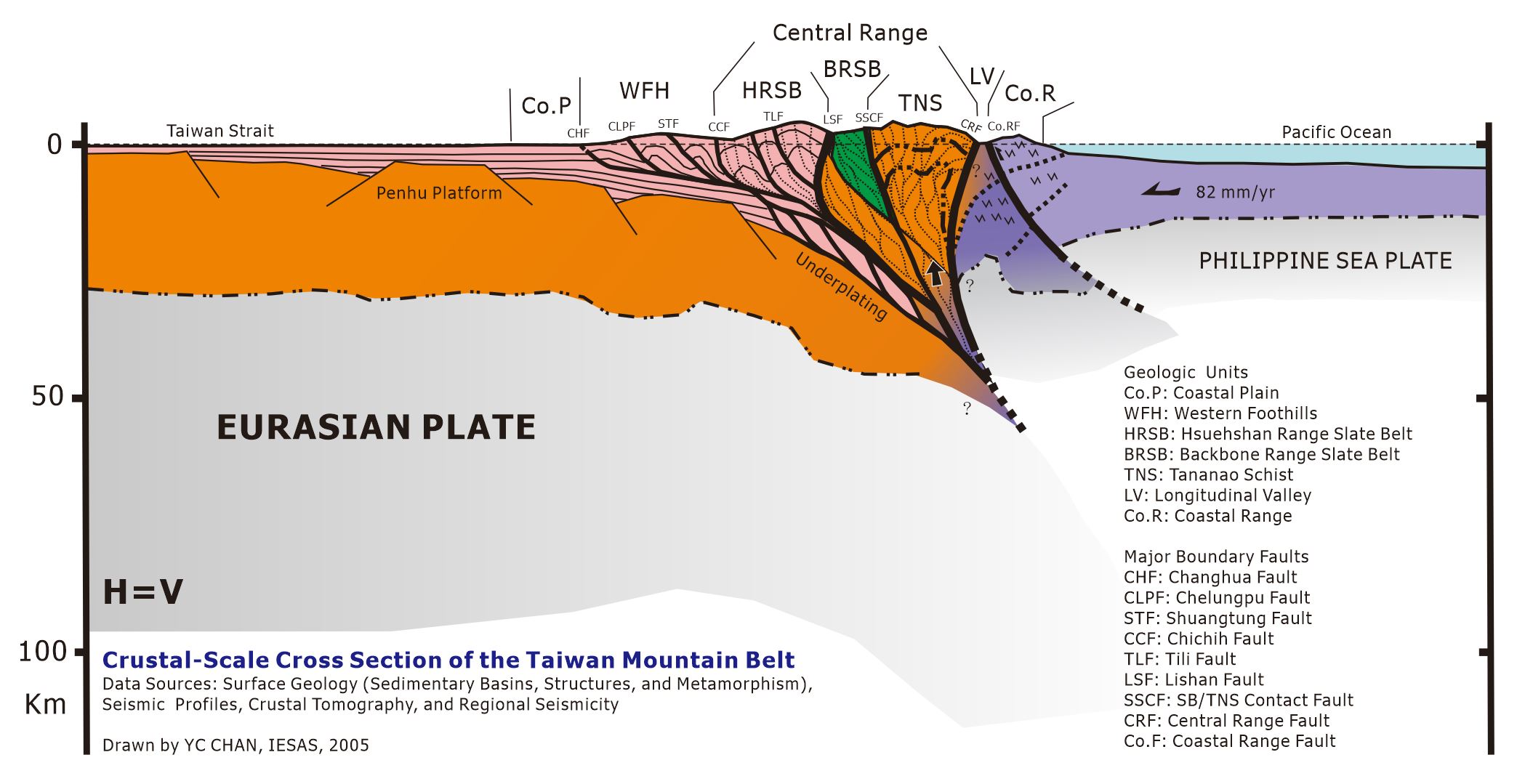
I created this crustal-scale cross section during my visit to Caltech in 2005 as an enjoyable exercise in synthesizing the tectonic architecture of the Taiwan mountain belt. The model integrates evidence available at the time from surface geology, sedimentary basins, major fault systems, metamorphic patterns, seismic profiles, crustal tomography, and regional seismicity.
From west to east, the section extends from the Taiwan Strait and the relatively stable Penghu Platform through the Coastal Plain, Western Foothills, Hsuehshan Range, Central Range, Longitudinal Valley, and Coastal Range. It illustrates how convergence between the Philippine Sea Plate and the Eurasian Plate has produced folding, thrusting, crustal thickening, metamorphism, uplift, and exhumation across Taiwan. The Longitudinal Valley represents the principal boundary between the Eurasian continental margin and the Luzon volcanic arc exposed in the Coastal Range.
The cross section reflects the geological understanding available in 2005, and some aspects have since been revised. One important change concerns the origin of the Tananao metamorphic complex, particularly the Tailuko and Yuli belts. In the original interpretation, these metamorphic rocks were broadly considered to be associated with the continental basement of the Eurasian margin. More recent studies, however, indicate that the Yuli Belt was largely derived from sedimentary sequences deposited in the South China Sea and subsequently incorporated into the Taiwan orogen through subduction, metamorphism, and tectonic accretion. Therefore, the Tananao metamorphic complex should not be regarded as a single, uniform exposure of continental basement.
This figure remains useful as a historical synthesis and conceptual framework, while also illustrating how interpretations of Taiwan’s deep crustal structure and tectonic evolution continue to change as new geological, geochronological, and geophysical evidence becomes available.
Figure: Crustal-scale cross section of the Taiwan arc–continent collision, drawn by Yu-Chang Chan during a visit to Caltech in 2005. The horizontal and vertical scales are equal. The interpretation represents geological knowledge at that time and has subsequently been revised, particularly regarding the origin of the Tananao metamorphic belts.
臺灣弧陸碰撞的地殼尺度構造 (2005)
我在2005年訪問加州理工學院期間,利用時間繪製了這張地殼尺度剖面圖,作為一項有趣的練習,嘗試整合臺灣造山帶的整體構造。這個模型彙整了當時我可取得的地表地質、沉積盆地、主要斷層系統、變質作用分布、震測剖面、地殼震波層析成像及區域地震活動等資料。
剖面由臺灣海峽及相對穩定的澎湖臺地向東,依序穿越海岸平原、西部麓山帶、雪山山脈、中央山脈、花東縱谷及海岸山脈,顯示菲律賓海板塊與歐亞板塊聚合所造成的褶皺、逆衝、地殼增厚、變質、抬升與剝露。花東縱谷則是歐亞大陸邊緣與海岸山脈呂宋火山弧之間的主要板塊邊界。
這張剖面反映2005年當時的地質認知,部分概念後來已有重要修正,其中之一是太魯閣帶與玉里帶等大南澳變質岩區的來源。當時多將這些變質岩概括解釋為歐亞大陸邊緣的基盤岩石;目前的研究則認為,玉里帶主要源自沉積於南海的沉積岩層,之後經由隱沒、變質及構造增積而成為臺灣造山帶的一部分。因此,所謂大南澳變質岩區並不能再被視為來源單一的大陸基盤。
這張圖仍可作為2005年臺灣造山帶研究的整合性概念模型,也反映科學解釋會隨著新的地質、年代學與地球物理證據而持續修正。
圖說:2005年於加州理工學院訪問期間繪製的臺灣弧陸碰撞地殼尺度剖面圖,水平與垂直比例相同。圖中呈現當時的地質概念;其中大南澳變質岩區的玉里帶的來源,後來已根據新的研究成果加以修正。